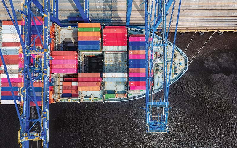
A recent report from the U.S. Army Corps of Engineers (USACE) supports deepening Wilmington’s harbor from its current depth of 42 feet to 47 feet, but the report has prompted concerns from local environmental advocates.
In September, the USACE released drafts of a letter report and environmental impact statement (EIS), marking the next step in a years-long process to evaluate deepening the harbor and adjacent channel. The report evaluated three alternatives and supported the 47-foot depth as the “tentatively selected plan.”
An N.C. Ports spokesperson said in a statement that the recommendation is “an important step forward in a process that will enhance port efficiency and strengthen our region’s competitiveness.”
According to the USACE report, the currently authorized depths in the channel around the port range from 25 to 44 feet mean lower low water, a measure of the lowest average water level. The port’s maximum sailing draft is 41 feet, with vessels with drafts greater than 38 feet required to transit during high tides, according to the report. The harbor’s depth has led to “navigation problems” affecting the port’s bulk and container ship operations.
“Cargo shippers are experiencing increased operating costs due to light loading, congestion delays, and tidal delays,” the report states. “These inefficiencies will increase in the future as present harbor users increase their annual tonnage throughput and as larger ships that require deeper channels replace older, smaller and less efficient ships.”
Since the completion of the last major channel improvements in 2002, the report notes that the Port of Wilmington has experienced “significant growth in cargo volume,” and the size of vessels calling at the port has increased.
“The cargo transportation industry continues to shift to increased use of standardized containers for multimodal (marine, rail, and truck) freight transportation systems. Additionally, the marine vessel fleet is trending to larger, deeper-draft vessels, particularly for containerships,” the report states.
Deepening the harbor would increase loading capacity for all vessels, especially larger ships, according to the report.
The harbor deepening would take approximately six years to complete, with a total cost of $1.35 billion to be paid for with a mix of federal and state funds.
Some local environmental advocates have questioned the need for the project. The report shows that while deepening the harbor could allow larger ships, it wouldn’t necessarily boost the amount of cargo coming through Wilmington’s port, said Cape Fear Riverkeeper Kemp Burdette. The report notes that cargo volumes are expected to continue climbing even without harbor deepening.
“Just because the N.C. Ports Authority wants to deepen the river doesn’t mean that we’re going to become a major port,” he said. “Charleston is always going to be bigger than we are. Savannah is always going to be bigger than we are. Norfolk is always going to be bigger than we are.”
Kerri Allen, a coastal advocate with the N.C. Coastal Federation, said while the group isn’t inherently opposed to the port deepening, “spending $1.3 billion for no net gain in cargo is hardly compelling.”
Both Burdette and Allen say they’re also concerned that sediment, which would be dredged as part of the project, hasn’t been tested for PFAS, or per- and polyfluoroalkyl substances. PFAS are chemicals that have polluted the drinking water supply in the Cape Fear River.
About half of the material dredged during the harbor deepening would be placed in intertidal areas, on local beaches for nourishment and in nearby bird islands and fish habitats, according to the report.
“If that sediment has PFAS in it, and you dump that sediment onto those low-lying areas, then you’re dumping contaminated sediment onto low-lying islands where birds nest and sea turtles might nest,” Burdette said.
Allen said testing the sediment would help her organization feel more confident in the project and provide a better understanding of its potential impacts.
Burdette would like to see more modeling of the impact the wakes of larger ships could have on habitats and properties along the Cape Fear River, and Allen, too, said she hopes to see more in-depth modeling of sea level rise impacts included in a final version of the report.
Both Allen and Burdette said they submitted comments on the proposed project during a public comment period, which ran through Nov. 3.
As for environmental impacts, the EIS identified a direct loss of fish habitat stemming from the proposed channel widening and deepening, along with indirect wetland function impacts from shifts in vegetation due to “increased salinity concentrations within the lower Cape Fear River.”
The drafts of the letter report and EIS will next undergo a series of reviews, along with the completion of the National Environmental Policy Act (NEPA) process. According to the report, final decisions on the project will be made following the NEPA process.