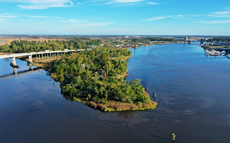
After more than two years of debate, New Hanover County leaders are working to establish the guard rails that will guide any future development on the western bank of the Cape Fear River.
The recent public debate over the largely undeveloped riverbank stemmed from plans for two large-scale developments submitted to county leaders in late 2021. In light of the proposals, New Hanover leaders opted to revisit the county policies that guide development on the riverbank opposite downtown Wilmington.
An update to the county’s existing comprehensive plan in 2016 aimed to guide denser development on the western bank, applying new commercial zoning to Eagles Island and establishing Riverfront Mixed Use zoning, but those types of development never came to fruition.
In 2021, New Hanover County received proposals for Battleship Point, a towering multiuse project, and a separate hotel and spa proposal on Eagles Island. Both projects have faced pushback from residents and environmental advocates. New Hanover County leaders have held two work sessions to discuss the western bank and received the results of a planning study on the area last fall.
Now, county staff are working to incorporate a new vision for the western bank in another revision to its comprehensive plan, the planning document that helps guide long-term land use. While county staff are updating the Comprehensive Plan, a process expected to wrap up by late 2025, they are fast-tracking changes for three areas of the plan, including the western bank guidelines.
That fast track is possible because of the work the planning department was already doing on western bank policy, New Hanover County planning director Rebekah Roth told the county’s planning board last month. Roth outlined the concepts that will guide the amendments and gathered feedback from the board at its March 7 meeting.
Roth said county staff will use the board’s input to develop a draft amendment that will be released for public comment later this spring. The county will then host public hearings on the proposed changes at meetings of the planning board and board of commissioners.
The county’s study has focused on nine parcels on the Cape Fear River’s western bank, all privately owned except the site of the Battleship North Carolina.
In its update, staff are looking to establish a development tier or place type specifically for the riverfront area, develop implementation strategies, articulate the land’s environmental constraints and outline monitoring studies and trigger points, according to Roth. The update also aims to ensure property owners and the public are aware of the risk and potential for future development and to find ways to shift the cost burden of new infrastructure off the public and onto the private sector.
The discussion with planning board leaders centered around the potential for residential development on the Cape Fear River’s western bank. Roth said increasing flooding in the area could put infrastructure and future residents at risk by isolating them and making them vulnerable to the floods.
“There’s a lot of uncertainties in this area about what’s happening in the future,” she said. “From some of the data trends, it looks like the amount of flooding is getting worse.”
Roth said staff expects “predominant uses” of the land to be civic and institutional along with commercial uses, which could include warehousing, light industrial or marine uses.
Some on the planning board raised concerns about the feasibility of commercial projects without a residential or mixed-use component. Planning board member Kevin Hine said he didn’t see how a project could succeed economically without a mix of uses.
“I don’t see how this can be successful without a strong mixed-use component that includes residential,” he said.
“The challenge with commercial but not allowing residential is that you’ve got to have the residential first to have the commercial,” added board member Cameron Moore.
Other planning board members expressed concern about allowing residential building on the flood-prone strip of land.
“If we encourage homes to be built in one of the most flood-prone areas in the county, we’re doing a disservice to our citizens,” said board member Clark Hipp. “That’s what I hear as something that staff is trying to limit.”
Moore believed a “form-based” zoning element would effectively ensure that any development met aesthetic standards.
The board also discussed adding incentives to encourage developers to add elements of resiliency into any proposed development. But some board members cautioned staff from dictating too closely what can and can’t be developed on the western bank, saying that developers need some leeway to make projects feasible.
Board vice chair Colin Tarrant said it will be challenging to establish exact guidelines before development starts on the western bank.
“It’s going to take a pioneer. It’s going to take someone who’s going to go over there and within the parameters that we are somewhat discussing here today to put something over there and to figure out how to make it work,” he said. “Until that starts to happen, it’s really hard for any of us, whether it’s staff or us as a board, to try to figure out how that’s going to fit together.”
Roth said staff will work on a draft of the amendments in the coming weeks. The proposed amendments will be given to the planning board for review before being released for public comment.


